The Berlin Wall
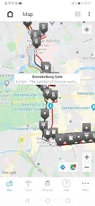
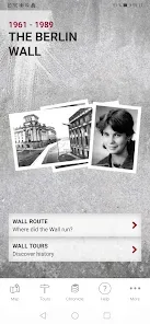
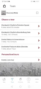
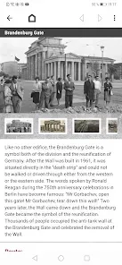
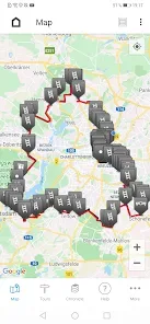
The Berlin Wall separated East and West for 28 years, two months and 28 days. It divided the city, ran through buildings, made streets impassable, tore families, friends and lovers apart. But where exactly did the wall run? The tool 'The Berlin Wall' gives a detailed answer. The exact course of the former wall is marked on an interactive map. At historically significant locations between the Brandenburger Tor and Potsdamer Platz, there are photos, audio clips and texts ready on the subject. A free data package with further information on places of historical significance throughout Berlin and Potsdam can be downloaded within the tool. The tool serves as an interactive travel guide on site as well as a general information resource. Functions- Overview map with the course of the wall and points of interest (POIs)- Filter option according to historical locations, escape routes, wall traces, exhibitions and monuments as well as border checkpoints- Recommended tours along the former wall- Navigation to the POIs- Connection to public transport- Film "Eingemauert! Die innerdeutsche Grenze" (in German)The tool is based on the website www.chronik-der-mauer.de and is a joint project of the Federal Agency for Civic Education, Deutschlandradio and the Leibniz Center for Contemporary History Potsdam. In November 2011, this tool won the most prestigious award in the field of political communication, the ”Politikaward”, and in 2012 it received the educational media prize “digita” and the “Comenius EduMedia” label.Data protectionThe tool can be used without exposing your personal data. Usage data is exclusively processed in order to provide you with the selected application or service. This information is neither stored within the application nor passed on to third parties.PermissionsIn order to be able to use the Berlin Wall tool to the complete extent, the tool requires access to the following functions:LocationPrecise localization based on GPS data and network informationIs required for:- Route planning & determination of the position on the map- Notifications when you are near a POI (explorer mode)Please note: Continuous background-use of GPS in the can significantly reduce the battery life. (It is used for the explorer mode.)Internet connectionShow network connection and network accessIs required for:- Grab of data packages, which contain most of the information about POIs & additional tours- Route planning- Link to the BVG website (Berlin public transport)Files & storageReading, changing and deleting the contents of your memory spaceIs required for:- Installation of data [email protected]

by Bundeszentrale für politische Bildung
Why people adore The Berlin Wall
Established by millions of people worldwide
Completely Free
A free data package with further information on places of historical significance throughout Berlin and Potsdam can be downloaded within the tool.
Speedy & Lightweight
Optimized performance that runs smoothly on any device without draining your battery.
User Friendly
Intuitive interface designed for everyone. Get started in seconds with no learning curve.
What people say
Rated 3.0 by 472 people
What sold me is how light it feels. No lag, no crashes, and it barely touches my battery.
I have recommended The Berlin Wall to two friends already. That says enough.
Been using The Berlin Wall daily for a couple of months now — smooth, stable, and every refresh makes it better.
See it in action
Explore the tool journey
Get in touch
Questions, feedback or a bug report — send it our way.
About The Berlin Wall
The Berlin Wall separated East and West for 28 years, two months and 28 days. It divided the city, ran through buildings, made streets impassable, tore families, friends and lovers apart. But where exactly did the wall run? The tool 'The Berlin Wall' gives a detailed answer. The exact course of the former wall is marked on an interactive map. At historically significant locations between the Brandenburger Tor and Potsdamer Platz, there are photos, audio clips and texts ready on the subject. A free data package with further information on places of historical significance throughout Berlin and Potsdam can be downloaded within the tool. The tool serves as an interactive travel guide on site as well as a general information resource. Functions- Overview map with the course of the wall and points of interest (POIs)- Filter option according to historical locations, escape routes, wall traces, exhibitions and monuments as well as border checkpoints- Recommended tours along the former wall- Navigation to the POIs- Connection to public transport- Film "Eingemauert! Die innerdeutsche Grenze" (in German)The tool is based on the website www.chronik-der-mauer.de and is a joint project of the Federal Agency for Civic Education, Deutschlandradio and the Leibniz Center for Contemporary History Potsdam. In November 2011, this tool won the most prestigious award in the field of political communication, the ”Politikaward”, and in 2012 it received the educational media prize “digita” and the “Comenius EduMedia” label.Data protectionThe tool can be used without exposing your personal data. Usage data is exclusively processed in order to provide you with the selected application or service. This information is neither stored within the application nor passed on to third parties.PermissionsIn order to be able to use the Berlin Wall tool to the complete extent, the tool requires access to the following functions:LocationPrecise localization based on GPS data and network informationIs required for:- Route planning & determination of the position on the map- Notifications when you are near a POI (explorer mode)Please note: Continuous background-use of GPS in the can significantly reduce the battery life. (It is used for the explorer mode.)Internet connectionShow network connection and network accessIs required for:- Grab of data packages, which contain most of the information about POIs & additional tours- Route planning- Link to the BVG website (Berlin public transport)Files & storageReading, changing and deleting the contents of your memory spaceIs required for:- Installation of data [email protected]
Tool Details
- Build
- 1.8.5
- Size
- 171 MB
- Category
- Travel And Local
- Developer
- Bundeszentrale für politische Bildung
- Content Score
- Everyone
Developer Info
- Developer
- Bundeszentrale für politische Bildung
- [email protected]
- Address
- 49 171 8318506
Primed to get started?
Grab The Berlin Wall today and join millions of delighted people.